October 15, 2013

Puentes de España

The Puente Ingeniero Carlos Fernández Casado -which takes its name from the construction engineer - spans the Barrios de Luna reservoir, in the province of Leon. It was built between 1981 and 1983 as part of the AP-66 or Ruta de la Plata motorway. It is a cable-stayed bridge, measuring 643 metres long and 22 metres wide, for four lanes, and was the longest cable-stayed bridge in the world at that time. It has two towers more than 100 metres high, which open at the bottom. Each tower has 27 pairs of front cables and 28 pairs of rear cables. The bridge is divided into three spans, the central span measuring 440 metres and the two side spans measuring 66 metres. A sliding joint was built into the central span to absorb expansion movements.
Carlos Fernández Casado (Logroño, 1905- Madrid, 1988) was one of the most prestigious and innovative civil engineers in his profession. From the outset, he specialised in resistant bridge structures, researching new materials in his own laboratory. Professor of Bridges, he examined archives and libraries and travelled the roads of Spain to classify bridges, Roman roadways, aqueducts and other civil engineering works to lay the foundations of the history of engineering.


The Roman bridge in the city of Mérida stands on the Guadiana river as part of the archaeological site of the ancient Augusta Emerita, the name by which the town was known in ancient times. It was built in the 1st century to facilitate communications with Hispania Baetica and give access to the city after the settlement of the Roman legions in town. It is 792 meters long with 60 round arches and it is considered to be the longest bridge of antiquity. It is built with a concrete core made of materials from the river and covered with granite padded blocks. It was originally divided into three distinct sections. The location where the bridge was raised was chosen taking into account the lower flow in that part of the river and because of the fact that the course was divided into two surges with an island in the middle which served to support the bridge. Over two thousand years of flooding and overflowing of the river have led to several restorations although the bridge still keeps its original construction in the part closest to the city known as the Humilladero.
The souvenir sheet depicts a view of the Roman bridge with its many arches.

  
The  Puente del Pilar, also known as the Iron Bridge crosses over the River Ebro in the city of Zaragoza. It was built in the late 19th century by the Spanish engineering company La Máquina Marítima y Terrestre specializing in the manufacture of metal bridges in the second half of the 19th and early 20th centuries. It was one of the first fixed bridges in Zaragoza since up till then the only fixed bridge in town was the 15th  century Puente de Piedra. In 1991 it underwent a restoration directed by civil engineer Javier Manterola in which two arched side boards were added for the passage of vehicles reserving the central platform for pedestrians. The metal structure was painted in blue and white, the colours chosen in a popular vote.

The Dragon Bridge crosses the river Guadaíra in the town of Alcalá de Guadaíra (Seville). It was built by the Civil Engineers José Luis Manzanares and Íñigo Barahona and opened on the 28th of March 2007. It is 123 metres long, with four spans: 43 metres the two central ones and 18.5 metres the two end ones. It was one of the first figurative bridges in the world and the first in Spain, and it emulates a dragon emerging from the Castillo hill and swimming across the river. Its inspiration comes from the architecture of Antoni Gaudí in Güell Park in Barcelona. The bridge is made of reinforced, pre-stressed concrete covered in "trencadis", a mosaic composed of pieces of ceramic and traditional tiles. It forms part of the Alcalá de Guadaíra bypass.

June 25, 2013

Europa 2012 - Visit Mostar

Mostar is a city in the valley of the River Neretva, in southern Bosnia and Herzegovina. It is the economic, cultural, educational, commercial and tourist centre of Herzegovina. Numerous archeological sites confirm that the broader area of Mostar has been inhabited since the Early Eneolitich, while during the Roman rule the area was inhabited by Illyrian tribes.
The city was named after bridge keepers (natively: mostari) who guarded wooden bridge which connected two banks of the River Neretva and for the first time the name Mostar is mentioned in the 15th century. After the fall of Bosnia under the Ottoman Empire, the Turks built the stone bridge in 1566, today famous as the Old Bridge. After the Berlin congress in 1878, the Turkish administration was removed by Austro-Hungarian administration. The valuable cultural monuments, oriental style buildings and Austro-Hungarian buildings have remained from that period which makes Mostar beautiful and interesting city.


The Old Bridge was destroyed during the terrible destructions in the last war from 1992 till 1996. It was renovated in 2004 and in 2005 it was included in the UNESCO list of protected monuments of cultural heritage as the first monument from Bosnia and Herzegovina. The Croatian Lodge „Herceg Stjepan Kosaca“, the center of cultural events of the city of Mostar, was built in 1959/1960. It is named after the ruler of Herzegovina, Duke Stjepan Vukcic Kosaca (around 1404-1466).
Today, Mostar is beautiful and hospitable city that enriches the different cultures and traditions with its beauty that makes it the city of open doors.

Stamp Issue: 2012.04.05

June 23, 2013

China-Turkey joint stamp issue

The joint stamp issue by Chinese and Turkish posts is dedicated to famous bridges of the both countries: the Yichang Yangtze Highway Bridge in China and the Bosphorus Bridge in Istanbul, Turkey.


The Yichang Yangtze Highway Bridge is a suspension bridge that crosses the Yangtze River some 20 km downstream from the center city of Yichang, China. The bridge was essentially designed to be extremely similar in appearance to the Golden Gate Bridge in San Francisco, USA. The construction of the bridge started on February 19, 1998 and it was open for traffic on September 19, 2001. It was a main span of 960 meters. As of 2012 m it is among the 30 longest suspension bridges, based on the length of the main span.


The Bosphorus Bridge is one of the two bridges in Istanbul, Turkey, spanning the Bosphorus strait and thus connecting Europe and Asia. It is a gravity anchored suspension bridge with steel towers and inclined hangers. The aerodynamic deck hangs on zigzag steel cables. It is 1,560 long with a deck width of 33.40 m and the total height of the towers 165 m. The Bosphorus Bridge had the 4th longest suspension bridge span in the world when it was completed in 1973, and the longest outside the United States. At present, it is the 19th longest suspension bridge span in the world

Stamp Issue:  2012.11.26

Puentes de España

The Bridge of Sancho el Mayor, in Navarra, crosses the river Ebro and is part of the A-15 highway. It was built in 1978 by civil engineers Javier Manterola and Leonardo Fernández Toyano and as a cable-stayed bridge. It has a total length of 204 meters, a width of 29 m and a main light span of 142 m, to which are added two side openings on the left bank of the river. It was built with precast keystones using the "cantilever" technique (the bridge is constructed in outward projections that are added on). This suspension bridge is supported on a single pier located on the axis of the road with 35 pairs of twin cables, At the time it was built it was one of the most innovative bridges in design and materials.

A typical cable-stayed bridge is a continuous girder with one or two towers erected above piers in the middle of the span. From these piers, cables are attached diagonally to the girder to provide additional support. Engineering wise they stand in between counter steel bridges and suspension bridges. This type of bridge began ito be built n the late 19th century and its use was widespread after World War II, thanks to the technical development of the construction materials and the structural empowerment via computers. 


Over the river Carrion in the city of Palencia stands the historic Puente de Puentecillas, the oldest bridge in town. Its original layout dates back to Roman times and it has undergone many changes since the 11th century, the most important of which took place in the 16th century when the current outline of the bridge was set and the remains of the Roman bridge disappeared. It stands in the city centre close to the Cathedral and other monuments and has become a popular walking area with plenty of green spaces. At the entrance of the bridge is the famous Bolo de la Paciencia, where washerwomen leaned their baskets of clothes while chatting. For years it has been a towns meeting place

Stamp Issue: 2013.06.20

Puentes de España

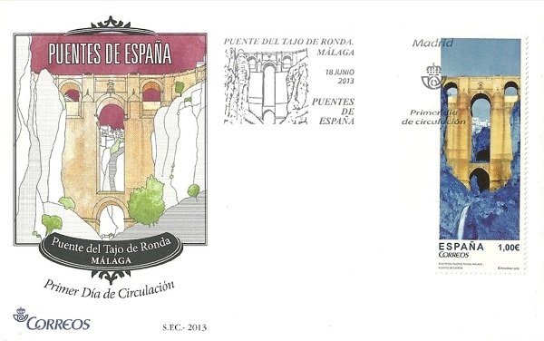
The Puente del Tajo, also known as Puente Nuevo, is the most characteristic monument of Ronda (Malaga). It was built between 1751 and 1793 over a 100 meters deep chasm made by the Guadalevin river. Its huge pillars settle deep into the gorge supporting a first central arch at the bottom which holds a much higher second one reinforced by buttresses. The work is completed with two lateral arches grounded on the rock. Parts of the span column interiors were used as a prison and now house an interpretation centre. It connects the old and the modern neighbourhoods of Ronda.
 The bridge was built with blocks of stone from the river gorge and it is considered a masterpiece. The building works lasted over 40 years and were conducted by several architects though Jose Martin Aldehuela was the key figure who also built the Ronda bull fighting ring. Both buildings are symbols of the city.

The Puente de Piedra in Logrono was built by Fermin Manso de Zuniga. It opened in June 1884 and is 198 meters long. It has seven arches standing on cylindrical pillars to span the bulk of the Ebro river. On the same location there stood a former bridge believed to have been built by San Juan de Ortega, which is why the current one is also known as Bridge of San Juan de Ortega. Due to landslides and heavy flooding, the original bridge was rebuilt several times until it was finally decided to build a new one on the remains of the old one. In 1917 the width of the Puente de Piedra was expanded with the construction on both sides of concrete pedestrian sidewalks, allowing for an increase in traffic.

Stamp Issue: 2013.06.18

June 20, 2013

Verranzano-Narrows Bridge

The Verrazano-Narrows Bridge, between Staten Island and Brooklyn, New York, is the longest single suspension bridge in the world. It is named for Giovanni da Verrazano, Florentine explorer who discovered New York harbor in about 1524. The massive span features a double deck thoroughfare, each wide enough for six lanes of traffic. The diameter of the cables measures 1 yard-identical with those on the George Washington Bridge. The Narrows Bridge is important in that it by-passes New York City. A map, illustrated on the stamp itself, pinpoints the positions of the Bridge with its close relationship to Staten Island and Brooklyn and also Manhattan and Jersey City, New Jersey.
Stamp Issue: 1954

The Mackinac Bridge Connecting The Peninsulas of Michigan

The Mackinac Straits Bridge extends over the Mackinaw Straits between Mackinaw City and St. Ignace, Michigan. The Mackinac Straits connects Lake Huron and Lake Michigan. The total suspension length of the span is more than a mile and a half between the cable anchors. The principle of the suspension bridge is that it has three essential parts: towers, anchorages, and cables. Towers for suspension bridges are built of stone or steel. Anchorages secure the ends of the cables, and most often are built of concrete or masonry. Cables are the most important element of a suspension bridge, since they carry the horrendous weight of the roadway.
Stamp Issue: 1958

The Golden Gate Bridge

The Golden Gate Bridge has the longest single span in the world, and the tallest bridge towers. Each of the cables has a diameter of one yard, and is composed of 27 thousand wires. Foundations have been sunk to solid rock 100 feet below water. The two main cables, each a yard wide, are outlined for the entire length by electric lights-magnificent evening sight. The Golden Gate Bridge and the Oakland-Bay Bridge were under construction at the same time; the Golden Gate Bridge is considered one of the most attractive spans in the world. The wonder of the extraordinary length of the span and the way it fits in with the site, make it one of the most exhilarating of bridges.
Stamp Issue: 1998

The San Francisco-Oakland Bay Bridge

In 1928, a San Francisco delegation urged Congress to pass a bill authorizing a bridge to connect San Francisco with Oakland and Berkeley-with 5 miles of water between. The legislation was defeated, but in 1932 Congress approved a $73 million loan with the endorsement of President Herbert Hoover. The first shovel broke ground in 1933, and 3 years later the span was opened to vehicular traffic with excited celebration. After competing ferries cut their fares in half in 1927, the bridge traffic amounted to 23 thousand vehicles a day. With the opening of the Golden Gate Exposition in San Francisco in 1939, tolls were reduced from 50 to 40 cents, and when cut further to 25 cents, the ferries gave up.

The roadway was built on two suspension bridges, with a central pier or anchorage at mid-channel. There are two decks: the top one handles six lanes for cars and light truck traffic. The lower deck carries three lanes for heavy trucks and multi-wheelers. There are also two streetcar (trolley) tracks provided. The structure is a combination of suspension and cantilever spans connected with a tunneled island.

Stamp Issue: 1939

The George Washington Bridge

The George Washington Bridge, over the Hudson River and dividing New York and New Jersey, is likely the heaviest and busiest of suspension bridges. Crossing the Hudson River at 178th Street, it is designed to carry huge loads. Twenty thousand tons of riveted steel for each tower was erected by massive derricks. Sixteen columns of steel 635 feet above water, as high as the Washington Monument, were put up.

The steelwork was planned early as a skeleton, and was to be covered by concrete and granite. However, as the steel skeleton rose, story by story, the unexpected attractiveness of the exposed steelwork fascinated virtually everyone who witnessed it. Consequently, massive appeals arose to "forget the masonry" that had been planned for the towers. Each of the four cables holding up the deck is a yard in diameter and a mile long. The 100,000 miles of wire could encircle the globe four times. Construction began in 1927 and continued for the next 4 years. Provision was made for an additional (lower) deck, which has since been added. The bridge opened to traffic in 1931. Of course it honors the name of the great General who managed to form the thirteen original colonies into one United States.

Stamp Issue: 1952

The Peace Bridge

The Peace Bridge has been significant in the growth of the country. It crosses the Niagara River from Buffalo, New York to Fort Erie, Ontario, Canada. The stamp commemorates more than a century of friendship, trade, and peace between the United States and Canada. The two nations share the longest undefended border in the world. New advances in construction have been used.

The Peace Bridge was built for pedestrian and vehicular traffic. Clearance at one end of the span is for canal or ship movement. The bridge is made up of five steel arches and a single truss span. At the elaborate opening ceremonies in 1927 a number of luminaries attended, including Edward, Prince of Wales.

Stamp Issue: 1977

The Brooklyn Bridge

In l869, actual construction of the Brooklyn Bridge, over the East River between Brooklyn and Manhattan, started. John Augustus Roebling, original architect of the project, was injured in an accident. Blood poisoning resulted in his untimely death. Fortunately his son, Colonel Washington Augustus Roebling, took over direction of the work involved from then on until completion. The grand opening was in May 1883.


This great bridge handles two elevated railroad tracks, two streetcar (trolley) tracks, road lanes for vehicles, and even a foot walk for pedestrians. Just to observe the massive stone towers one is in awe of their height. They had to be lofty to carry the cables which in themselves-wire by wire-measured 16 inches in diameter. Tons of steel wire had to be used to hold up the incredibly heavy bridge deck.
With the long main span, and two shorter spans, the bridge is 1 mile long. It is constructed of four cables, each anchored to plates of many tons, embedded in masonry foundations. Each foundation has a weight of 44 thousand tons. Every cable contains more than five thousand steel wires-a total of fourteen thousand miles of wire. It took thirteen years to build the bridge. At present thousands cross it each day. Even this writer, when working in New York, walked across this Bridge with friends and couldn't help but marvel at the magnificence of it all.

Stamp Issue: 1983

The Mississippi River Bridge

The Eads Bridge over the Mississippi River at St. Louis was constructed from 1867 to its opening in 1874. The structure was built by Captain James Buchanan Eads, and is considered the first bridge made of steel. The U.S. Postal Service preferred to attach the sobriquet "Mississippi River Bridge" rather than employ the proper, personal, private name "Eads."


The span is double deck, with the upper level carrying a highway with sidewalks. On the lower deck, two lines of railroad tracks fill the space. This marks the first time steel is used in truss-bridge construction. A franchise was obtained from Congress specifying that a clear span of 500 feet must be provided. A report, published by Captain Eads in 1868, was a convincing presentation in non-technical language, on the "action of trusses and arches, also the logic of the foundation design." Progress, along with precautionary measures, were recorded in notebooks that filled seven volumes.
Funding for the Bridge building came from contracts with the Keystone Bridge Company of Pittsburgh, Pennsylvania. The Vice President was a young man of 35 years by the name of Andrew Carnegie. His connections with Eads were numerous. In his autobiography, completed shortly before his death, Carnegie credited his connection with Eads Bridge as starting him on his career. To this day the span is in full use.

Stamp Issue: 1898

June 2, 2013

Puentes de España

Besalú Bridge is located in the medieval village of the same name in the province of Gerona. It began to be built in the 11th century to save the river Fluvia and establish communications between the town and the land on the other side of the river. It consists of seven pointed arches spread over 145 meters forming an oblique angle at the centre which divides it into two sections. On the side that gives access to the city stands a defensive tower built in the mid 14th century where watch was kept and travellers and merchants passing through were obliged to pay a toll. In the centre of the bridge a second defensive tower was built over a pronounced oblique angle, substantially higher than the first one and opened at the bottom by a pointed arch.

The Roman bridge is five meters wide and over the centuries it has witnessed floods, flash floods and devastating conflicts having to be reformed in the 14th and 17th centuries. During the Spanish Civil War it was partially blown up and in the 1960s it was completely rebuilt following the original structure and aesthetics. In recent times a parallel concrete bridge has been built for traffic preserving the historic medieval bridge for pedestrians. Besalú is located in the region of La Garrotxa, and is one of the main tourist towns in the province of Gerona in which art and history blend giving way to an attractive historic centre. The porticoed streets, the bridge, the Jewish baths and Romanesque churches form a top medieval compound. In 1966 it was declared a "national artistic and historical town".

The stamp dedicated to the Bridge of Los Santos sobre la Ría de Ribadeo links the towns of Ribadeo (Lugo) and Castropol (Asturias) and is a highlight of civil engineering. Over the vast estuary of Ribadeo was built, from 1983 to 1987, the Bridge of dos Santos which communicates Asturias and Galicia and overcame the gap separating these two regions thus facilitating communications between both sides.
The bridge is 600 meters long and was initially 12 meters wide. From 2007 to 2008 it was widened in 24.60 meters converting it to four lanes and two sidewalks to allow for the Cantabrian motorway (A-8) to pass through it. It is a trabeated bridge made of reinforced concrete, steel and wood which can carry a weight of over 1,200 tons.The bridge is named after the chapels on either side of the river: San Román nas Figueiras in Castropol, and San Miguel, in Ribadeo. Before the building of the bridge, communications between both sides were by boat or making a detour along the old road between Vegadeo and Porto. The issue is a one stamp souvenir sheet featuring an aerial view of the estuary and the town of Ribadeo. In the stamp is depicted the modern bridge of Los Santos and the town of Ribadeo
Stamp Issue: 2013.05.04

May 30, 2013

Reconstruction of the old bridge in Mostar

The Mostar Bridge is one of the greatest masterpieces of structural engineering of the Ottoman times. It is part of the oldest nucleus of the town and has great environmental value in its urbanistic structure. Its specific position is harmonized with the natural configuration of the terrain, while its architectural value has been achieved by the usage of basic structural elements. The surrounding mountains leave a deep impression on the viewers, together with the deep river bed of the blue-green river Neretva and the houses characterized by the typical ambiance significance for the 15th and 16th centuries. The oldest written document about medieval Mostar dates back to the 15th century, before the advent of the Ottoman Empire’s administrative management. The document was the work of Duke Stjepan Radivoj, (a Herzegovian nobleman). Little is known about the building of the bridge. What remained written are only memories and legends, as well as the name of the great architect Hayruddin. Even nowadays, when parts of the bridge have been rescued from the Neretva and examined all the constituent parts of the bridge, there still remains the mystery of how the scaffolding was built, how the stone got transported from one side of the river to the other, how the scaffolding endured the long period of construction, as well as numerous other “minute” constructional problems, those that we encounter nowadays despite the usage of the most modern technologies at our disposal. This speaks for the high quality of the builder’s expertise, his idea, never to be repeated or written down but realized in a work that doubtlessly belongs to the greatest engineering undertakings of its time. There were no archaeological finds to be discovered in the position where the present bridge with its towers fortifying it on both banks stand, which might draw to the conclusion that the bridge with its fortifications and the settlement that belongs to it could be dated to earlier periods than the Late Middle Ages. The fortifications together with the bridge were invaded by the Ottoman Turks round 1470, and there they organized a military outpost for further military attacks in western Herzegovina and Dalmatia. During the time of Ottoman administration, near the fortifications on the bridge, particularly on the left bank of the Neretva, a trading-crafts centre started developing, the origin of today’s Mostar. The suspension bridge built in the Middle Ages continued to connect the two banks of the river Neretva, and the Turks continued using it until the middle of the 16th century. Along the rather ramshackle wooden suspension bridge, in 1557, due to the order of Sultan Suleiman ‘the Magnificent’, the construction of the single span, stone arch bridge was built according to the project of the then supreme Turkish architect Kodja Mimar Sinan, and by the year 1566 it was erected and completed by his pupil and assistant Mimar Hayruddin. The medieval towers on the banks that guarded the approach to the bridge from both sides of the river, were reconstructed and extended many times, at the time of the Ottoman administration and particularly at the time of the Candian war, but basically retained all their essential elements that they had been given, probably in the 15th century, by their medieval builders. Around the Old Bridge a community developed that was to become a trading and crafts centre.

During the period of the last fifty years, this site was subjected to numerous conservation and archaeological research undertakings. The conservation work was supposed to examine and restore damage on the bridge and its accompanying towers, as well as check on the data about their building that were partially preserved in the reports of the later travel writers and some scattered historical sources. In the course of the research and the restoration work, the foundations of the bridge and the river banks have been underpinned and consolidated, and the supportive parts of the bridge, together with the support pillars have been injected. The bridge arch has also been injected, and the damaged stone blocks exchanged. Lesser damage was repaired by mortar mixed from white cement and ground limestone that was used in building the bridge.

The Old Bridge in Mostar was destroyed by shelling in November 1993, in the course of the recent wartime events. Its rebuilding began in the year 2002 under the auspices of the World Bank and the Bank for Development of the Council of Europe, with funds donated by countries like Italy, Turkey, Croatia, The Netherlands and France. After two years since the beginning of its restoration and almost 15 million US dollars spent, the work is approaching its end. The main responsibility lay upon the Turkish company ERBU, specialized for the restoration of Ottoman bridges, working under permanent supervision of specialized Croatian companies and experts. From the oldest times up to the present, the Old Bridge has remained the symbol of Mostar. The bridge also remains a permanent attraction for the population as well as tourists. The tradition of taking jumps from the top of the arch into the river also remains a symbol that will be transferred to future generations.

Stamp Issue: 2004.07.23

May 29, 2013

Bridges and viaducts

Old Josephine Road was passing along Salopeke Modruške, a fortification of Modruš and next to the St. Nicholas monastery at Kapela. In order to surmount the steep rocks above the Tounjčica canyon, a 45 m long stone bridge with three openings was built. The bridge was erected at the time when the building of the road began, in 1775 and from 1833 to 1835 the road was renovated from Senj through Mala Kapela to Tounj in the length of 76 kilometres. New road was meant to avoid steep terrain, so from Josipdol to Donji Modruš it had a smaller number of rises than the old route. Then the building of the second floor of the bridge at Tounj began. The lower floor of the bridge, built in 1775 was in use as an integral construction for about sixty years. In 1836 the second floor was added to it, what made steep rises and descents of the road toward the bridge as well as sharp curves somewhat more moderate.


According to the preserved original designs and photographs, it is evident that on the first part of the bridge from both sides there were four statues. Above the pillars there were huge statues of Roman soldiers, while smaller statues above base pillars disappeared. Before the Second World War only their pedestals were preserved. On both sides of the bridge, on the parapet, there were slabs with inscriptions. On the first slab of white limestone there was an inscription in Latin: “To the memory of the difficult passage that in May 1775 the Emperor Joseph II, father of homeland, first undertook and ordered that new road be built under the guidance of the enthusiastic constructor, colonel Struppi”. On the other slab made of dark limestone there was Latin inscription: “Ferdinand I, Emperor of Austria, religious, happy and illustrious, added to the bridge of the divine Joseph II, Roman Emperor, erected between steep shores, a new, easier access and renovated the whole road in 1836  entrusting the works to Kajetan Knežić, supreme commander of border guards.”
On the bridge on each floor there are three openings spanned by semicircular vaults. The vaults are 5.6 m large and the pillars are 2.6 m wide, with parapet 9m.  The second floor of the bridge is 12.35 m above water. Between the parapets the bridge is 7.8 m wide and with parapets 9 m. The width of the roadway is 6 m. The height of the parapet is two times multiplied by 0.6 m. Pedestrian pathways are 0.9 m wide and the upper floor is 5.6 m high.

During Second World War a greater part of the upper floor, three vaults and their pillars were destroyed. Later, a provisional wooden crossing was constructed over these remains.  In 1956 at the Institute for Wooden and Massive Bridges of the Technical Faculty in Zagreb a technical elaboration for bridge renewal in its original form was prepared. The statues and commemorative slabs from the bridge are partly preserved. One statue is exposed near the bridge, on an elevation not far from Tounjčica, while another statue with the commemorative slab from the year 1836 is situated in the yard of the Frankopan Castle in Ogulin.

Stamp Issue: 29.04.2013

May 24, 2013

The Črni Kal Viaduct

 With its 1065-metre length, a surface of 28,173 square metres and a maximum pier height of 95 metres, the Črni Kal Viaduct is both Slovenia's longest motorway bridge and its tallest structure. The viaduct was built as a part of the new motorway linking Ljubljana, the capital, with the Slovenia costal region (Klanec – Srmin section) in the period between November 2001 and September 2004. The viaduct is the most demanding structure built on Slovenian motorways in terms of functional requirements, construction and technological capacity, design requirements, the difficult installation into the environment linked with the preservation of natural environment, as well as in terms of investment costs and easy maintenance. The viaduct consists of two separate carriageway superstructures that rest on joint Y-shaped piers. The shape of the piers is the main element of design that is a special distinctive feature of this Slovenia's largest viaduct, thus making it stand out among similar bridging structures abroad. In designing the project, road safety, protection from strong gusts of north-east wind and black ice were the main guidelines. A special 3–3.5-metre high wind barrier will protect drivers from strong gusts at this lofty height, while the road surface ice sensors will provide road condition information to road maintenance service in Kozina

Stamp Issue: 2004.09.15

The chain bridge at Stádlec


The chain bridge at Stádlec from 1848 was originally built in Podolsko on the Vltava (Moldau) but after the Orlík dam was built it was moved to its present location on the Lužnice and put back into service in 1975. It is the only bridge of its kind in the Czech Republic which has been conserved.

Stamp Issue: 1999.05.26

Wooden bridge in Cernvir


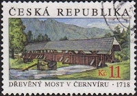
The wooden bridge across the river Svratka in the middle of the village of Cernvír near Tišnov dates from 1718. The wooden beam construction supported by stone pillars is covered by a shingle saddleback. The historical road to Pernštejn castle led across this bridge until 1839; today the bridge is only used by pedestrians.
Stamp Issue: 1999.05.26